Skip 52
Member
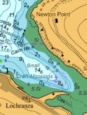
Does anyone know what the legal situation is regarding anchorages shown on admiralty charts? I ask because recently we have tried to use a couple of designated anchorages around Arran - the attached example image is from the Memory Map/UK Hydrographic Office chart of Lochranza. The anchorage area is clearly shown on the chart, but in fact there are now at least six mooring buoys within that area. Which makes it totally unusable when using a 6x rode. Highly necessary here - an anchored yacht was blown onto the rocks earlier this year.
Any advice gratefully received!
Any advice gratefully received!


 . At least there was no wind that night.