Ijmuiden to the IJsselmeer (North Sea Canal)

SYGalatea

New Member
Joined
13 Sep 2020
Messages
4
Visit site
Hello.
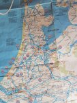
I’m helping a friend bring his newly purchased yacht back from the Netherlands in a week or twos time. We’re thinking of taking the North Sea Canal route via Amsterdam, entering the canal from the Ijsselmeer and then entering the North Sea at Ijmuiden. But we’re short on pilot books! Can anyone offer any tips/advice re locks, bridges and any other local navigational issues?
we’ll be making the passage in a Sweden 42.
Thank you!
 
Dead easy, two sets of locks , one set at Ijsselmeer and one set at Ijmuiden. Canal is straightforward , can get a bit busy around Amsterdam
 
Thanks. And is it obvious how to enter the locks? I heard that you had to go through a particular lock as a small craft? (Are there large ship and small craft locks side by side?)
Also are there any bridges that might cause an air draught issue for a 42 footer?
Thanks again.
 
If coming from Ijselmeer there is a lock at Enkhuizen (naviduct) into the Markermeer, or a lock Lelystadat the eastern end. Then a lift bridge just East of Oranjesluis ( can't remember the name, probably Julianabrug?). Then Oranjesluis (can get busy but should be OK out of season. Then straight through to Ijmuiden. Kleineslus for yachts near south side. The marina is sea side of lock. You can sail if wind is fair (seldom) but no tacking. Watch out for ferries near Central station.
Bridge and lock times are in the manual or just Google them or call on vhf, channel will be displayed. Very frequent in summer, not sure about now?
 
Last edited:
Perfect.
Another quick question, this time about the Ijselmeer. We’ll be coming from Andijk, so we need to get through the Houtribdijk dam somehow (all 20+ miles of it). I’m assuming that there is a lock (which must be on marked on the charts). Any tips for this? Are there fixed opening times for example?
Thank you!
the road goes through a tunnel so no bridges. The lock near Enkhuizen is one of the simplest in Netherlands. Lots of room to tie up or wait if you have to. Call on vhf (marifoon) if you need more info.
 
One problem you may have on that route is weed on the Markermeer. Quite a problem in high summer, not sure about now. If you slow down much try backing up to clear it.
 
Perfect.
Another quick question, this time about the Ijselmeer. We’ll be coming from Andijk, so we need to get through the Houtribdijk dam somehow (all 20+ miles of it). I’m assuming that there is a lock (which must be on marked on the charts). Any tips for this? Are there fixed opening times for example?
Thank you!
Many years ago we used this to navigate for the first time North > South
 

Attachments

  • 20200913_181404.jpg
    20200913_181404.jpg
    370.7 KB · Views: 6
  • 20200913_181339.jpg
    20200913_181339.jpg
    406.7 KB · Views: 8
We got caught out a couple of years ago because the road bridge at the East end of Amsterdam doesn't open for a fairly long period during the rush hour. Definitely check the times for that one.
 
Isn’t it all in Dutch though?
[QUOTE="SYGalatea, post: 7338937,
Yes it is but the relevant bits are easy to understand. You may need to look up a few words. The numbers are in meters.
It may be obvious but worth mentioning the bridge / lock signals.
Red .no entry
Red and green together. About to open, get ready.
Green. Proceed.
Occasionally you will get 2 reds. Closed after hours or breakdown. Unlikely on your route.
 
Isn’t it all in Dutch though?
Yes, but easy enough to interpret symbols and depths / air clearances etc. As Dan Tribe says - it's not a standalone solution for navigating but if you're planning a trip and don't have a chart or pilot book to assist the planning, it will help...
 
Although quiet, there will probably be one or two local boats around and you could do worse that follow them and do what they do. The locks and bridges are controlled in and out by lights, red - no entry/passage, red/green prepare to go, green to go. Two reds, closed for an extended period. The Dutch don't tolerate ditherers, so be ready to move off smartly. I usually have the boat moving at half speed on the red/green, and with some bridges it is acceptable to proceed while red/green is showing. I have tended to turn it into a game, so that the light turns to green just as I arrive at the bridge.

With a two-way bridge, the traffic passing first will be given the red/green light while the others are held on red.
 
Top