Forecast Wind Arrow Frustation

What happened to those, since you mention it :)
I had to step back, and the developer accounts weren't monitored. Warnings to update the Android app weren't received and the app was deleted from the Play Store.

When I later tried to help, we ended up in classic Google developer support/login hell, and didn't manage to sort it. There seems little motivation in current Chimet management to address the problem.

Not sure about the iOS version!

Instead of resurrecting the mobile apps, it would be better to make the web versions mobile friendly. However, knowing their architecture, I'm not sure that would be easy.
 
Much of operational meteorology is defined by WMO to ensure common practice world wide.
I do not know what happens at the coal face now but weather charts used by forecasters were plotted from data received in synoptic messages. Winds were/are shown by a line towards the station with feathers showing speed. The table here shows westerly winds.

The other diagram shows how “weather” was/is plotted so that a forecaster could see, easily, what weather is occurring over a wide area. A long way from current forecasting.

For use on apps such as the MetOffice one it is more intuitive to use symbols as shown here for N to NEasterlies.
 

Attachments

  • IMG_7164.png
    IMG_7164.png
    1.7 MB · Views: 5
  • IMG_7163.png
    IMG_7163.png
    1.3 MB · Views: 5
  • IMG_7167.png
    IMG_7167.png
    476.4 KB · Views: 5
There seems little motivation in current Chimet management to address the problem.

Understood... except that it is a very minor problem really. Everyone using it will know what the forecast was (and if it's me then I'll already probably be sailing in the actual wind), plus direction is given in words alongside the graphic.

Chimet.png
 
Understood... except that it is a very minor problem really. Everyone using it will know what the forecast was (and if it's me then I'll already probably be sailing in the actual wind), plus direction is given in words alongside the graphic.

View attachment 209994
I was referring to the mobile app problem.

Window arrow shape/direction was a non-problem, IMO. Bigger things to worry about.
 
The direction deviation seems a new thing, but I’m not too sure what it is telling me?
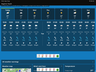
Maybe 'deviation' here refers to change in wind direction in gusts?

Only Chimet offers this premium service, neither Bramblemet nor Sotonmet have it (while Esmet and Cambermet simply don't work at all).

There is currently considerable divergence in wind and gust speeds between the three. How much is this is real due to different topologies in what is effectively the same local area (factoring in neither land or sea-breezes at 8.00am, but maybe something to do with mini katabatic-like winds sweeping down off the South Downs to the NNE?), and how much maybe down to dicky kit? (Bramblemet has in the recent past, i.e. last year, shown completely wrong wind direction.)

Chichester:
cmet.png

Bramble:
bmet.jpg

Southampton:
smet.jpg
 
Last edited:
Taking my usual cynical approach, I mote that the problem is that weather apps from unofficial sources, eg the Solent AWS, do not necessarily conform to international standards. I have seen wind arrows with feathers pointing in the wrong direction. In the Solent example, they show gust speeds but give a Beaufort equivalent. That shows ignorance on their part. Meteorologists recognised the need for standardisation in weather as long ago as 1853. Johnny come latelies do not always recognise that there are often good reasons for seemingly tedious rules. The bits of this thread that I have read make the point.


.
 
The real problem is that most forecast use the same data, but no two forecasts agree completely on such things as base wind speed and maximum gust - so presentation may be the least of the issue

We use met office inshore forecast combined with wind guru to get better idea of wave height with the limits of actual projected journey

Just looking at the sky at sky helps also
 
*
The real problem is that most forecast use the same data, but no two forecasts agree completely on such things as base wind speed and maximum gust - so presentation may be the least of the issue

We use met office inshore forecast combined with wind guru to get better idea of wave height with the limits of actual projected journey

Just looking at the sky at sky helps also
I suggest you read the New Scientist article, August 2026, “Why are weather forecast apps so terrible.”
They put it down to the jiggers pokers by the interpretation/fiddling by the various firms. My advice is to stick to National Weather Service forecasts and apps. At least they will be officially wrong. 😎
As regards looking at the sky, your horizon may be so limited that you get minimal warning on some occasions.
 
*

I suggest you read the New Scientist article, August 2026, “Why are weather forecast apps so terrible.”
They put it down to the jiggers pokers by the interpretation/fiddling by the various firms. My advice is to stick to National Weather Service forecasts and apps. At least they will be officially wrong. 😎
As regards looking at the sky, your horizon may be so limited that you get minimal warning on some occasions.
I subscribe to new scientist so will look it up. I assume you mean a 2025 article.

For what it’s worth, sailing in s Cornwall the wind is so deflected by big cliffs and moors that local direction will often be very different to main weather flowl
 
Top