Deben Entrance May 2020

Johnah

Well-Known Member
Joined
28 Apr 2019
Messages
115
Visit site
Hi all,

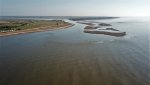
Here is a small video of the Deben entrance at LWS as it is now (May 2020) with the new buoy positions.

Deben Entrance May 2020

Plus an aerial photo.

Please do not use these for navigation, but refer to the Deben Estuary Pilot website Home or East Coast Pilot East Coast Pilot

Although this latest video on the Deben Estuary website may not be uploaded yet.

The line is closer to the shore than last year as the bar depth on the old track has become shallower.

John
 

Attachments

  • DJI_0054 (2) (1287 x 722).jpg
    DJI_0054 (2) (1287 x 722).jpg
    190.3 KB · Views: 120
Tried out the bar for real yesterday at 10.15 which was 1 3/4 hrs before HW - (midday) in a SE F2-3. My Moody 31 draws 1.6m and the lowest depth measured below the keel was 1.3m - (in a position between the two red buoys), giving 2.9m minimum.

I think my depth gauge is reasonably accurate but can never be sure it is spot on.

Interestingly, the Harwich Harbour Tide measurement for 10.10am was 2.92m. Tide - Harwich Haven Authority

So maybe a good measurement of minimum depth of water at the bar is to check the HHA web page and take that as close to what it is, as the bar level seems to be close to the chart datum height.

In my mind that makes sense as the Deben is always still emptying even at LWS, and the bar has never been visible right the way across, or at least where the buoys are positioned.

John
 
Both the Deben and even more so the Ore keep dumping out long after low water.
Depending on the various channels through both shingle bars the incoming tide also adds to this especially at Shingle Street where it has to turn 180 to start back up river. Low water Orford quay is about the time it starts to flood properly upstream there.
 
Think that is why the green buoy is so close - to stop people running wide.

Here is my chart-plotter track from two days ago (21st May).

Where the tracks diverge is after the last red buoy.

On the run out I turned out to sea - but not directly at the safe water buoy, and on the return I came in parallel to the shore.

So don't follow my tacks South of the last red, but there was enough depth on these tracks close to HW.


John20200521_114753.jpg
 
Top